Next month, the City of Hamilton plans to install parking-protected bike lanes on Charlton Avenue West and Herkimer Street between Dundurn Street South and James Street South.
By Ryan McGreal
Published August 17, 2015
Next month, the City of Hamilton plans to install parking-protected bike lanes on Charlton Avenue West and Herkimer Street between Dundurn Street South and James Street South.
In an email to Ward 2 Councillor Jason Farr, members of the Durand Neighbourhood Association (DNA) and Raise the Hammer, Public Works Alternative Transportation manager Daryl Bender confirmed that staff are modifying the design of the bike lanes, which were originally supposed to be installed in late 2014, and will have the modified design completed by the end of August.
Staff plan to meet with Councillor Farrr and the DNA in early-mid September to review the new designs.
Last September, signs appeared on Herkimer and Charlton advising that bike lanes were to be installed in October.
")
Herkimer Bike Lane Installation sign, October 2014 (Image Credit: Kyle Slote)
Durand resident Kyle Slote contacted Councillor Farr to ask for more details about the designs and was advised that the City was planning to narrow the existing automobile lanes and install painted lanes on the right side of each street that would run through the "door zone" of curbside-parked cars.
On Herkimer, the eastbound bike lane would start at Locke Street and end at MacNab Street rather than extending from Dundurn to James. Shared-use bike sharrows would be painted between Dundurn and Locke.
On Charlton, the westbound bike lane would start at James and end at Locke.
None of the intersections would be treated with bike boxes to facilitate left turns.

Old design for Charlton and Herkimer bike lanes
Neighbourhood advocates objected to the design, arguing that the bike lanes should be physically protected - for example by locating them to the right of the parallel parked cars - and the intersections should include bike boxes for safer left turns. They also argued that the lanes should connect with the existing bike lanes on Dundurn Street South.
In response, the City put the installation on hold pending more consultation with the Ward 1 and 2 Councillors and representatives of the neighbourhood association to resolve the safety issues.
A working group struck by the DNA came up with a design for parking-protected bike lanes that would fit on Charlton and Herkimer and shared it with staff earlier this year.
In addition, cycling advocate Kevin Love presented research from the New York City Department of Transportation which concluded that parking-protected bike lanes significantly increase ridership while reducing crashes, collisions and injuries to all road users - cyclists, pedestrians and drivers alike.

Proposed redesign for Charlton and Herkimer bike lanes
As of this past April, staff were working on updated design drawings but could not provide a target date for installation.
Earlier this month, in response to a follow-up query from RTH contributor Jason Leach, the City responded by confirming that a new design for parking-protected lanes is imminent.
According to Bender, staff will install the Charlton and Herkimer lanes after painting bike sharrows on Queensdale Avenue, and then installing bike lanes on Cannon Street on between Gage Avenue and Britannia Avenue (connecting Cannon Street to the Pipeline Trail).
")
Pipeline Trail (RTH file photo)
The design for the bike lanes on Charlton and Herkimer has not been finalized and is not yet available for preview.
By bad council? (anonymous) | Posted August 17, 2015 at 15:40:39
so what about joey & council responsibility?
By mdrejhon (registered) - website | Posted August 17, 2015 at 17:17:21 in reply to Comment 113436
It would be nice to have had Joey Coleman monitor all of this.
But, I think, however, this was an excellent city move. A delay to improve safety and increase cycle use. And the modification doesn't take any car lane away; it simply juggles the ordering of the lanes around for greatly increased safety -- to facts-based safety successes in other cities...
This introduces improved bike infrastructure into Hamilton, utilizing quieter streets, considering we out-bikeshared Toronto and the Cannon bike lanes are getting more popular, especially on summer weekends. There is latent local cycle demand that has long been stymied by lack of safe bike routes.
Comment edited by mdrejhon on 2015-08-17 17:28:37
By Pxtl (registered) - website | Posted August 17, 2015 at 16:21:45
Looking forward to this. Hopefully this kind of design can be the New Normal for Hamilton.
By mdrejhon (registered) - website | Posted August 17, 2015 at 16:49:35
I'm looking forward to a finally having a safer biking route to Locke area. I think these are relatively good choices for bike routes.
I hope the city uses green paint to mark these bike lanes, or at least for the bike boxes. We need more green-colored bike infrastructure paint in Hamilton. And of course, co-ordinate with SoBi for some minor tweaks in SoBi rack locations to optimize access to these new bike lanes.
Comment edited by mdrejhon on 2015-08-17 17:01:30
By mdrejhon (registered) - website | Posted August 17, 2015 at 17:08:39 in reply to Comment 113440
On this note, the question of Cannon bike lane extension to Pipeline Trail:
Comment edited by mdrejhon on 2015-08-17 17:08:50
By KevinLove (registered) | Posted August 17, 2015 at 18:36:19 in reply to Comment 113441
At the meeting of the Hamilton Cycling Committee on August 5 this was part of the presentation of Daryl Bender. Cannon Street between the end of the protected bike lanes at Sherman and the protected Pipeline Trail will have unprotected bike infra. Nothing but paint. And in one place, only sharrows! Yikes!
This will result in two nice pieces of protected bike infra with an unprotected gap between them. A formula for failure since less than 8% of the population is willing to use unprotected bike infra.
Comment edited by KevinLove on 2015-08-17 18:44:08
By mdrejhon (registered) - website | Posted August 18, 2015 at 09:36:38 in reply to Comment 113443
There is a new school about to be built near the stadium and some schookids will ride on bike. We need more details on certain sections like the section of Cannon Bike Lane nearest the school. If sharrows near Sherman are involved, then at the very minimum, an intervention is needed for the sake of the children's safety -- even at a minor delay to the Cannon bike lane section between Sherman and Gage -- considering the dangerous Sherman-Cannon intersection.
There is extreme danger approaching the school from the west, crossing Sherman. Sharrows near Sherman would be completely unacceptable to children, for example, considering the confusion/complexity of that intersection. I see kids dangerously going diagonal, and sometimes biking wrong-way (riding eastwards on the westwards bike box east of Sherman).
At your next meeting, please raise this issue of the need for school safety.
The Sherman In Motion group which I now attend (small Sherman Hub community group on transportation issues) is currently interested in the quality of the planned bike infrastructure nearest the new school. They are currently unaware how much/little protection there will be. There's already an invite out to one of the cycle stakeholders to attend the next meeting about proper bike lane protection leading up to the new school.
Comment edited by mdrejhon on 2015-08-18 09:48:14
By MattM (registered) | Posted August 18, 2015 at 00:06:32 in reply to Comment 113443
Another classic example of the city half ass'ing bicycle infrastructure. They're still not getting it.
By jason (registered) | Posted August 18, 2015 at 09:20:53 in reply to Comment 113453
made even more frustrating by the fact that Cannon was completely torn up and re-built as part of the stadium project. Would have been very simple to add raised bike lanes (which should become the new city standard, along with parking protected lanes).
By mdrejhon (registered) - website | Posted August 18, 2015 at 09:33:22 in reply to Comment 113462
The master "new road" template needs to be changed so that new road construction incorporates this on key bike routes. Sidewalks need to also be included -- they are missing on some mountain roads that could use them!
Let's make sure we're part of getting the template changed; I think they're about to make amendments.
Comment edited by mdrejhon on 2015-08-18 09:33:55
By jason (registered) | Posted August 18, 2015 at 13:22:59 in reply to Comment 113463
There was talk a year or so ago from city hall about changing how they build roads to go from 'sidewalk-in' instead of 'centre line-out' as it always has been. Zero evidence of this yet however with butcher job on West 5th and same old re-builds on Cannon near the stadium, Concession, King St Stoney Creek, Claremont Access, Beckett Dr etc.....
Comment edited by jason on 2015-08-18 13:23:37
By DBC (registered) | Posted August 17, 2015 at 19:59:44
Does anyone know if there will be any changes to rush hour parking restrictions?
By kdslote (registered) | Posted August 18, 2015 at 10:34:44 in reply to Comment 113444
Our group recommended eliminating the morning rush hour lane on Herkimer, but we still have not seen any of the city's revised designs to know if it will be modified. We observed that the amount of traffic on Herkimer in the mornings does not require two lanes. If anything, there is more traffic in the afternoon when people are heading to the James Street mountain access and Jolley Cut, but rarely is there any congestion with just one lane!
By Pxtl (registered) - website | Posted August 18, 2015 at 11:04:50 in reply to Comment 113466
This is why I wish the city would streamline John Street South. That's one case where I think the street needs more driving capacity, particularly Southbound. It would encourage drivers to take the most direct route from King/Main to the Jolley Cut instead of scrambling through residential roads in Durand.
http://www.citylab.com/commute/2013/01/c...
describes a compromise between 1-way and 2-way streets where left-turns are banned except where specifically accommodated. It describes this as providing the best trip-serving capacity since it allows both clear wayfinding without constant blockages from left-turns. Get rid of the silly TWINO (two-way-in-name-only) version of John and the inexplicable single lane of access to the Jolley and make John a proper connection.
With John South properly connecting drivers to the Jolley Cut, James South and the various Durand one-ways would be less appetizing for drivers through downtown. Then put bike lanes on James South since it's no longer a southbound TWINO artery.
Comment edited by Pxtl on 2015-08-18 11:05:42
By mdrejhon (registered) - website | Posted August 18, 2015 at 13:01:49 in reply to Comment 113467
TWINO -- Two Way In Name Only -- good one; I'll need to remember this!
By ergopepsi (registered) | Posted August 17, 2015 at 21:13:27
I say good work by the city for accepting community input and for acting on it.
By KevinLove (registered) | Posted August 18, 2015 at 16:48:05 in reply to Comment 113448
Except the City has not yet acted upon it. The design is neither completed nor approved. I'll believe it when I see it.
By fmurray (registered) | Posted August 17, 2015 at 22:47:32
This design will make a huge difference when I'm biking home from work along Herkimer. Currently, having to "share" a lane from Queen to Hess on Herkimer results in cars speeding along to get past me and then cutting into the lane to turn left at Hess.
I have high hopes that these bike lanes will slow traffic along Herkimer, and Charlton too.
By kdslote (registered) | Posted August 18, 2015 at 10:20:04
Thanks for the update Ryan!! I'm optimistic that the work of citizens will result in lanes that are better designed than the city's original design...but I'm very interested to see how far they will go towards a best practice design.
By brendansimons (registered) | Posted August 18, 2015 at 14:27:38
I'm hopeful to hear the city is adjusting its plans to meet resident demands. This could be a good first test of "parking separated bike lanes", giving the city experience with an option between expensive curb-separated lanes (Cannon) and ineffective? painted lanes (Dundurn and everywhere else).
I'm a little concerned about the narrow parking on the right side of the street. This is similar to what they did on Cannon, and it means that people getting out of their car risk "dooring" passing traffic, and getting hit as they exit their cars if they aren't careful. OTOH, being so close to parked cars may force traffic to slow down - a particular problem on Herkimer and Charlton. Have their been any accidents resulting from the narrowing of the parking lane on Cannon?
By ergopepsi (registered) | Posted August 18, 2015 at 14:59:21 in reply to Comment 113473
The 'dooring' danger exists currently on Herkimer - both for bikes and oncoming cars despite the current width of the road. Drivers often aren't paying attention and are going too fast to swerve if suddenly confronted by a door. I always do a shoulder check before getting out of my car and I wait until all cars have passed before getting in.
The major benefit of this change for me is the traffic calming which will make the street safer for everyone. I was initially concerned about my car getting sideswiped but I don't think it will be a problem. Drivers will move more slowly as the narrower path will force them to pay more attention.
Another point, between Dundurn and Locke, traffic will be a nightmare for pickup and drop off at St Joe's but I bet it will be far more manageable for the poor crossing guard at Herkimer and Locke who currently has to manage four crossings where very often there are three cars lined up at Herkimer waiting to turn left, turn right and cross Locke along with cars coming from both directions on Locke.
Maybe some of those parents will drop their chubby little YouTube-heads off a block away and have them walk gasp 300 metres to get to school.
By mdrejhon (registered) - website | Posted August 18, 2015 at 14:39:35 in reply to Comment 113473
Parked cars also tend to hug the curb better on narrow parking lanes. I know I do, parking only a couple inches away from the curb.
What we however badly need, is painted markings for street parking spots.
Especially on Main and King. The mere prescence of painted rectangles on the road surface, has a minor car-taming tendancy while also advertising themselves -- few cars park on Main/King even offpeak since many don't want to park on an expressway, and many don't even notice the parking meters as they stare at the road surface keeping up with speed. More parked cars will help businesses and incrementally tame Main/King a little bit before major more-dramatic steps occur as LRT construction approaches closer.
Mere simple painted parking markings is a low-lying apple that appeals to the people-friendly mindset and auto-friendly mindset -- possibly as an interim step for future incremental people-friendly improvements or overhauls. This would be an excellent first step to begin this year, long before bumpouts, construction detours, and 2-way streets. Perhaps this should be be done for Charlton/Herkimer, if possible.
Comment edited by mdrejhon on 2015-08-18 14:45:40
By ryanwestdale (registered) | Posted August 18, 2015 at 15:26:19
This smells like a victory. I really want to get involved and help make more of this kind of stuff happen in Westdale - anybody on here involved in a Westdale complete streets group of some kind?
By moylek (registered) - website | Posted August 18, 2015 at 22:53:48 in reply to Comment 113480
anybody on here involved in a Westdale complete streets group of some kind?
Not that I'm aware of. In a way, Westdale has been relatively passive when it comes to things like bike lanes and complete streets. Perhaps because we already have things pretty good compared to the rest of the city? Because we already have a lot of cycle and pedestrian traffic? I'm not sure.
But there is room for improvement and I bet we would get support from our councillor.
I've wondered before if the AWWCA shouldn't spawn a cycling or complete-streets committee.
By ryanwestdale (registered) | Posted August 28, 2015 at 12:48:04 in reply to Comment 113492
thanks moylek,
I went and joined the AWWCA as a start. Looks like there is potential for a greenway out of Westdale and we really need traffic calming on the residential streets (Marion, Bond South for example). We also have very inconsistent bike lane coverage, as does the rest of the city.
By LDC (registered) | Posted August 18, 2015 at 17:17:37
I'm still not convinced of the need for a protected bike lane on Herkimer between Locke and Dundurn. Starting at Locke, definitely. But between Locke and Dundurn - cyclists, pedestrians, and motorists (including school buses, and DARTS buses) seem to coexist safely and peacefully. Anyone want to try to to explain this one to me? There must be a reason this is a good idea if it was part of the old plan and it was scrapped, and I'm open to hearing the reason!
By aksher (anonymous) | Posted August 19, 2015 at 19:39:52 in reply to Comment 113482
I live on that part of Herkimer too and disagree. Cars come down Dundurn from the 403 and use Herkimer as a freeway to get to the hospital. It does get worse block by block as you approach the hospital, but that's only speaking relatively. It also gets wider after Locke. Compared to my previous home near the HAAA I'd say I get 1/4 the bike and pedestrian traffic.
By mdrejhon (registered) - website | Posted August 18, 2015 at 19:25:02 in reply to Comment 113482
There are Dundurn bike lanes -- continuity of the bike lane network is essential for increasing bike use. If we start at Locke, then there's no continuity or discoverability of a bike lane grid in Hamilton. This decreases bike use noticeably, as bike uses increases in other cities by precedent if the lanes are connected.
Even if you were right (Herkimer resident ergopepsi, between Locke and Dundurn, suggests otherwise), the above reason is reason enough, too.
In addition, a third reason: The city agreed with the resident preferences to have bike lanes all the way to Dundurn, including residents living on that said section.
By fmurray (registered) | Posted August 20, 2015 at 20:15:49 in reply to Comment 113487
Speaking of continuity, a bike box on Dundurn for left turns at Herkimer would be a great addition. It's difficult to find a break in traffic to move over to the left there. Sometimes I use the ped-activated light and the crosswalk. A bike box would be better.
By kdslote (registered) | Posted August 21, 2015 at 10:05:42 in reply to Comment 113572
Agreed! This was one of our recommendations to city staff. Hopefully they implement this!
By Pxtl (registered) - website | Posted August 18, 2015 at 23:52:45 in reply to Comment 113487
Speaking of continuity, it would be nice to see the Hunter lanes continued west past Queen, even if it's just signs and sharrows on that final leg of Hunter and Canada, and a little pavement up to Dundurn.
By ergopepsi (registered) | Posted August 18, 2015 at 18:02:07 in reply to Comment 113482
As a resident of that stretch I've never felt safe riding on that part of Herkimer and I can see it in other riders as I approach from behind in my car. They move way over, slow down, duck in between cars obviously not comfortable with the feeling of a car coming at them. I also don't let my kid ride on the road because the cars drive way too fast - he rides on the sidewalk. Now he can get off the sidewalk and ride in a protected lane and everyone else can do so as well without fear of being run over.
Comment edited by ergopepsi on 2015-08-18 18:02:25
By nickpas (registered) | Posted August 20, 2015 at 10:22:36
This may have something to do with city staff attending a spring Book 18 training session on bike facility design -- where parking protected cycling infrastructure is now codified into provincial design guidelines.
By mdrejhon (registered) - website | Posted August 21, 2015 at 01:39:11
For people who want a better understanding of parking protected bike lanes, a brand new video has appeared on Vimeo:
It's an excellent video about parking protected bike lanes!
By mdrejhon (registered) - website | Posted August 23, 2015 at 17:55:50
I have created a new animated GIF about Parking Protected Bike Lanes based on the video at www.vimeo.com/cupola/speck3
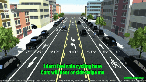
This is a good way to win skeptical automobile owners too because, you know, #hamont is a strong automobile population.
Permission granted to any RTH author for usage in any future articles about parking protected bike lanes, please credit www.vimeo.com/cupola/speck3 as that is the original I derived using framegrabs. I also have a much bigger 1920x1080 animated GIF, please contact me for the two original GIF frames if you want something bigger.
Comment edited by mdrejhon on 2015-08-23 18:01:20
You must be logged in to comment.
There are no upcoming events right now.
Why not post one?