If we want to change the way people choose to get around, we need to change the way we design our streets.
By Ryan McGreal
Published December 02, 2014
At last Wednesday's packed-house Love Your Streets seminar, we learned that half of all driving trips in Hamilton are a distance of five kilometres or less. Even more amazing, more than half of all trips one kilometre or less are taken by car. (Citizens at City Hall has an excellent write-up on the event.)
Of course, this outcome is the predictable legacy of decades of automobile-dependent street design and land use planning. If we want to change the way people choose to get around, we need to change the way we design our streets.
On that note, the New York City Department of Transportation is building a protected two-way cycle track to connect Long Island City in Queens with Greenpoint in Brooklyn on the Pulaski Bridge over Newtown Creek. Here's a conceptual drawing of what it will look like, courtesy of Brownstoner Queens:
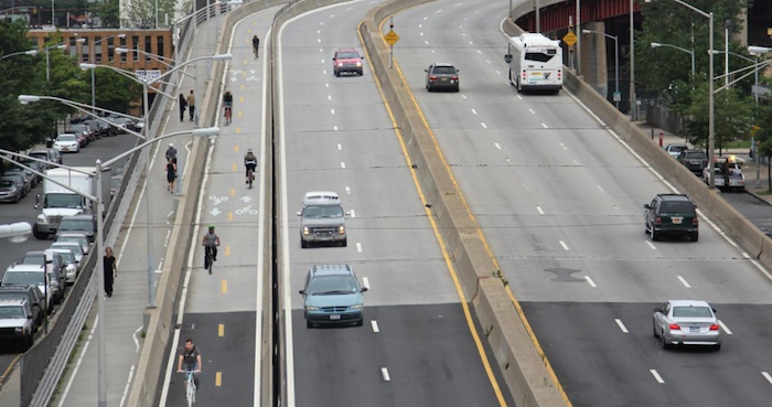
Conceptual illustration, Pulaski Bridge protected cycle track (Image Credit: Brownstoner Queens)
This would be perfect for a lane on the Claremont Access to connect Wellington Street/Victoria Avenue in the downtown core with West 5th and the mountain.
Jason Leach first proposed this three years ago in an article on building a network of what he called "bicycle superhighways", but are generally referred to as protected cycle tracks.
At the start of this year, Jason reiterated his call to build a protected cycle track network from the waterfront right up the mountain, making better use of our excessive overbuilt arterial streets.
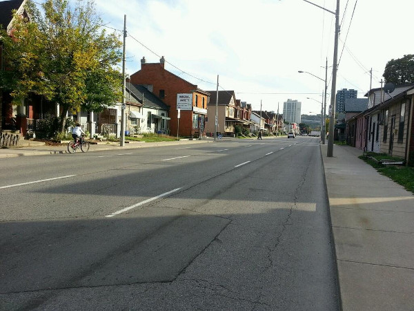
Wellington Street during afternoon rush hour (RTH file photo)
As he noted, this would connect the student population at Mohawk College to downtown Hamilton, connect downtown to the waterfront and could easily connect with the Escarpment Trail, which passes directly under the Claremont Overpass.
Repurposing a lane of the Claremont Access for cycling is a no-brainer. The freeway-style access is grossly overbuilt for the volume of automobile traffic it carries.
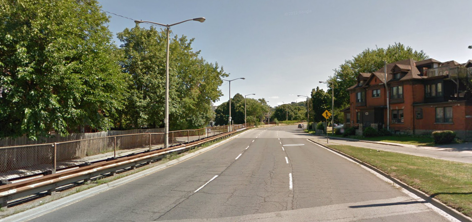
Claremont Access: a freeway running through an urban neighbourhood (Image Credit: Google Street View)
The easternmost downbound lane has been closed for two and a half years after a rock slide blocked it, and city staff have no plans to re-open it.
We could easily take an upbound lane and convert it to a protected cycle track with absolutely zero impact on automobile traffic.
Since then, Hamilton has built its first protected cycle track along three kilometres of Cannon Street between Sherman and Hess. So now we have demonstrated that we are capable of building a good cycle track (even though we haven't applied that capability to other routes yet).
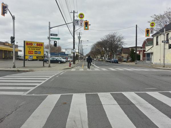
Cannon Cycle Track at Wentworth (RTH file photo)
A cycle track running up the Claremont Access and down Wentworth would cross the Cannon Cycle Track on its way to the waterfront, providing even more connectivity across different parts of the city.
And of course, the City's plan to develop the waterfront just begs for integrated, proactive investments in real, high-quality multi-modal transportation options so people choosing to live there don't have to drive for every trip.
As we keep saying on RTH, we get the city we plan for.
We are also about to launch a new bike share program that will provide 750 bikes at 100 stations across the lower city between downtown Dundas and Gage Avenue.
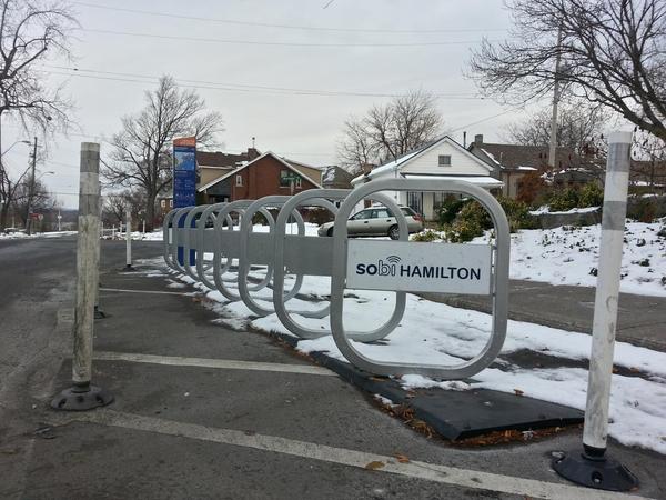
Bike share station, Bay and Macaulay
The bikes will be deployed in a "beta release" over the winter for people who are already members, with an official launch and ribbon-cutting scheduled for March 20, 2015. (In the meantime, you can still buy a one-year membership but the year won't start until after the launch.)
There are only a few stations on the mountain, but the plan is to expand the program to more stations and more bikes as demand grows. This is the perfect time for the City to support active transportation by building a high-quality connection between the mountain and the lower city.
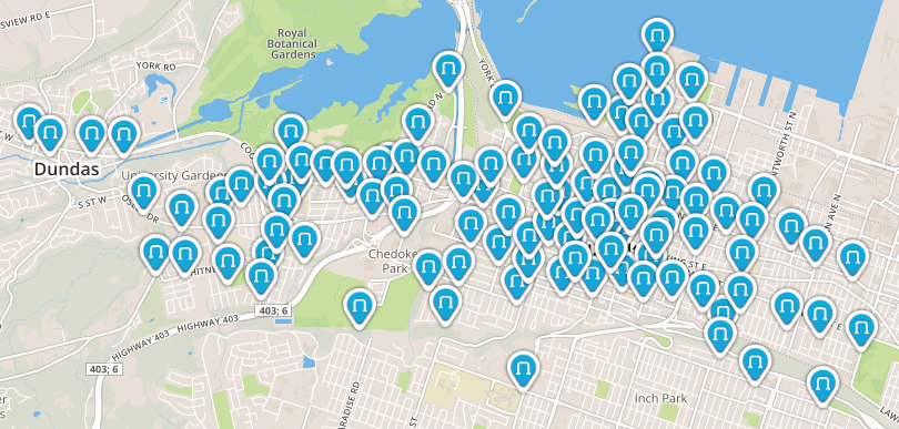
Map of Hamilton Bike Share Stations (Image Credit: Hamilton Bike Share)
In Hamilton, we have been putting far too many of our transportation eggs in just one very expensive basket.
The price we must pay includes unsustainable infrastructure lifecycle costs, worse air pollution, higher levels of obesity, heart disease and diabetes, economically depressed neighbourhoods, and vulnerability to service interruptions.
It's time to redesign our streets for a much wider variety of uses by making dedicated, safe space for walking, cycling and transit.
As we can already see with the Cannon Cycle Track, when you build high-quality infrastructure, people use it. Within weeks of opening in mid-September, Cannon Street was already attracting 250-400 cyclists a day, up from almost zero.
We get the city for which we plan. It's really that simple.
With files from Jason Leach
By VicGedris (registered) - website | Posted December 02, 2014 at 15:53:38
This would be excellent on the Claremont Access.
There would have to be some important design considerations to take into account:
There's certainly spare capacity, and it should be easy to do.
[Begin reminiscing...] 20 years ago, when I lived in Hamilton right near the top, it was about a 7-8 minute bike ride to a friend's place near the bottom, bombing down as fast as we could on our "mountain" bikes, wind making my eyes tear up. At least 30 minutes riding back, and hellish on hot days. Although the downhill speed was crazier, I was usually more scared going uphill as the speed differential was so much different and there has never been much of a shoulder, from what I recall. A protected lane would have made that downright leisurely (well, shade would have helped too).
By holdtight (anonymous) | Posted December 02, 2014 at 16:09:50
Growing up on the edge of the mountain me and my friends attempted the ride up and down the claremont on a couple of occasions.
It is very very very steep, we would blow down the Claremont so fast the bike would start to tremble and the brake would melt. Scary stuff, and we were 14 yrs old. Riding up... well we would make it about 100m and walk until we got to the bruce trail and scoot over there. Great idea in theory but god help the Mohawk student whose brakes fail.
By Fake Name (anonymous) | Posted December 02, 2014 at 16:53:45 in reply to Comment 106516
Anybody know if the Cootes' Drive speed warning signs work on bikes?
By point? (anonymous) | Posted December 04, 2014 at 07:02:48 in reply to Comment 106518
Does anyone care?
Apparently, bikes travel like a cloud and could never damage anyone or anything, and can't ever go fast enough to do any harm.
By timmeh (anonymous) | Posted December 04, 2014 at 03:32:01 in reply to Comment 106518
Yeah, they even work if you get into the lane and run at them. We had a running speed contest there one night till the cops chased us away..
By Henry and Joe (anonymous) | Posted December 02, 2014 at 17:55:09 in reply to Comment 106518
Haven't tried it, because I always take the multi use trail when I am coming up the hill from Dundas.
The sign coming down off the Kenilworth access definitely works. My record is 47 km/h on my bike. I think I could crack 50, but I don't want to break the speed limit ;)
I like to take that route to the Cannon cycle track. That reminds me. Does anyone know why left turns on Cannon from Kenilworth are prohibited?
By Fake Name (anonymous) | Posted December 02, 2014 at 16:16:12
Skip adding a new divider. Just use the 2 South side lanes, so the existing concrete divider separates pedestrians from drivers. Then you don't need any expensive new concrete, and 3-4 lanes of the North side can carry the meager traffic of the Claremont just fine. Just draw a yellow line on the North side and fix up the intersections at the top and bottom, and declare the South side to be a combined pedestrian/cyclist space. Other mountain accesses lack a concrete divider, why does the Claremont need one?
By Cyclomaniac (anonymous) | Posted December 02, 2014 at 18:14:46
Let's see how the Cannon experiment works out first before we lay one more meter of bike lane. I don't know if people are angrier about bus only lanes or about Cannon bike lanes the most. But the least we should do is study what we have to see if critics are wrong or the enthusiasts are.
By j.servus (registered) | Posted December 04, 2014 at 09:52:57 in reply to Comment 106521
Why don't we do it the other way around, and experiment with a series of unconnected car lanes? Then we can test how many people drive on them, and decide whether to build more.
Comment edited by j.servus on 2014-12-04 09:53:30
By jason (registered) | Posted December 02, 2014 at 19:10:14 in reply to Comment 106521
Or perhaps we could learn from the rest of the world and understand that the more high quality infrastructure we build, the more people will use it. If NYC waited to see gobs of people cycling the bridge pictured in the article above, they'd never build a protected cycle track. Just like roads and highways, if you build it, they will come. Not the other way around.
Tons of cyclists on Cannon today in the snow and cold FYI.
Re: climbing the Claremont. Would seem a perfect time for one of these:
http://www.slate.com/blogs/atlas_obscura...
Comment edited by jason on 2014-12-02 19:11:35
By Noted (anonymous) | Posted December 02, 2014 at 22:50:08
"The road course starts at City Hall on Main St E and proceeds west to Queen St where it turns south to the Mountain Brow and up the 1st ascent an approx 1.5 km hill ascending 150 metres on Beckett Drive to Garth St from which it quickly turns onto Fennell Ave over to Upper James (all flat). The course then turns north on Upper James back to the brow and down the Claremont Access onto Victoria Ave to Main St which it uses for one block turning south again at Wellington onto the Claremont Access back up the Mountain approx 2.5 km where the route flies over the James Mountain Rd , loops round back onto 5th Ave and down James Mtn Rd a sharp swift drop of about 75 metres onto James St South to Main St E and back past City Hall. Neither climb represents a severe grade - probably 3-7 % on Beckett Drive and 5% on Claremont. The James Mtn descent however is closer to 10%."
hamiltoncycling.com/world_cycling_championships_2003.htm
Q: How long can a bicycle lift be?
A: Based on calculation, there is a maximum length of 500 meters.
trampe.no/en/faq#5
By Noted (anonymous) | Posted December 02, 2014 at 23:18:04
More on the Pulaski Bridge project (one of the last NYC DOT projects brought forward by Janette Sadik-Khan):
nyc.gov/html/dot/downloads/pdf/2013-12-pulaski-bridge-bicycle-path.pdf
By Ms Me (anonymous) | Posted December 03, 2014 at 07:23:31
Does anyone know how many memberships bike share has sold to date?
By does it matter? (anonymous) | Posted December 03, 2014 at 09:07:16 in reply to Comment 106531
I don't suspect that number means anything until there are bikes on the ground. We did see a working bike at the love your streets event. There are supposed to be bikes available in the winter, which is awesome news - we will for sure have a smattering of nice weather stretches through winter plus anyone who doesn't want to ride their own bike in the salt will benefit. But I think membership numbers won't mean much until the weather breaks in spring.
By Ms Me (anonymous) | Posted December 03, 2014 at 13:47:58 in reply to Comment 106534
Yes it does matter otherwise I wouldn't ask. I'm sure there are target numbers that have to be met by March otherwise a March start up will be delayed.
By news (anonymous) | Posted December 03, 2014 at 15:38:15 in reply to Comment 106551
I've never seen anything that implies there's a minimum number of memberships required before the bikes will launch... did you read that somewhere?
By Ms Me (anonymous) | Posted December 03, 2014 at 16:02:56 in reply to Comment 106554
No I haven't heard or read anything, however basic economics would dictate no money no product or service. By your lack of answer I'll assume they are still sitting at 1% sold. Boy they have a long way to go.
By news (anonymous) | Posted December 04, 2014 at 09:20:55 in reply to Comment 106555
whose lack of answer? the anonymous commenting area of this site?
By PartyOfOne (anonymous) | Posted December 06, 2014 at 18:08:23
Best part of this garbage piece: No casual cyclist can ride up that access.
By DowntownInHamilton (registered) | Posted December 09, 2014 at 18:14:24 in reply to Comment 106655
You;d have to ask Ryan and Jason since it's their piece.
Maybe they can grab a tandem from Bikehounds and test out their suggestion?
If you just want to get rid of a lane, say so. It could get closed off with bollards, concrete dividers, whatever, and you'd be set.
By mountain guy (anonymous) | Posted December 06, 2014 at 20:56:44
Why has nobody considered running the future a line lrt up this access instead? Take two upbound lanes so it can utilize tge underused w5th ramp. It would save james st s and the west 5th access from construction hell and needless hole drilling in the escarpmemt as well as still providing direct connections to mohawk college and upper james.
By kevlahan (registered) | Posted December 09, 2014 at 18:19:48 in reply to Comment 106662
It was considered and it is technically feasible given the grade, but the problem is that it would involve running the LRT along several kilometres where there is little to no possibility for economic uplift ... and it is longer.
In any case, the plan for the medium term is for LRT along the Main/King corridor (where demand and economic uplift potential is highest) and BRT along the A-line route.
By jason (registered) | Posted December 09, 2014 at 19:01:54 in reply to Comment 106814
just don't tell trucking lobbyist John Best....CHML's go-to expert on why electric LRT is horrendous and will end the world.
By Fake Name (anonymous) | Posted December 09, 2014 at 18:24:21 in reply to Comment 106814
I've been wondering, can LRT trains have switches/junctions as part of their regular route? That is, could the hypothetical Claremont A-line LRT use the B-line King tracks to get to James, or would it need its own dedicated track?
You must be logged in to comment.
There are no upcoming events right now.
Why not post one?