For a car driver, the route to a given destination is usually simple and straightforward. Cycling should be the same.
By Kevin Love
Published July 22, 2015
RTH editor Ryan McGreal recently provided a recent description of his trip to Limeridge Mall and the dysfunctional lack of bicycle infrastructure to get him there and back.
That article inspired me to describe part of my bizarre daily commute to work. In my opinion, my commute is also an excellent example of the dysfunctional lack of bicycle infrastructure that people in Hamilton have to put up with every day.
I live in the Durand neighbourhood near Durand Park. I work in East Hamilton, about 10 km away. Dear reader, as you read this article, please ride along with me in your imagination. Let's ride together for the first part of my commute to work, from Durand Park to the Cannon Street cycle path.
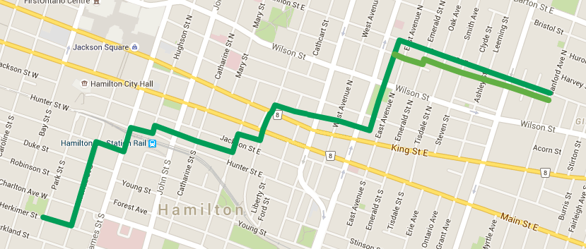
Bike commute route (Image Credit: Google Maps)
From Durand Park, we will ride eastbound on Herkimer to McNab Street. Then we turn left onto McNab and ride north four blocks to Bold Street. Next we turn right onto Bold Street and one block later turn left onto James Street. Then (Scary! Scary!) we ride under the James Street underpass under the railway tracks, taking the lane on James Street with heavy motor vehicle traffic. This is NOT a pleasant experience.
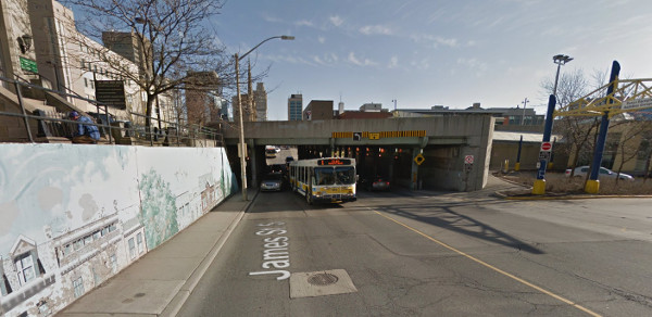
James Street railway underpass - Scary! (Image Credit: Google Street View)
Many people ride on the sidewalk under the James Street underpass, but I do not. There is heavy pedestrian traffic on this narrow sidewalk, and I am one of the 1% who is willing to take the lane in order to exercise lane control on roads with motor vehicle traffic. So I do.
From James, we turn right into the GO station property at Hunter Street. As we see in the photograph, the sidewalk goes off to the left next to the street and a multi-use path goes to the right at the base of the elevated rail lines. We will take the multi-use path to the right, and then turn left onto Hughson Street.
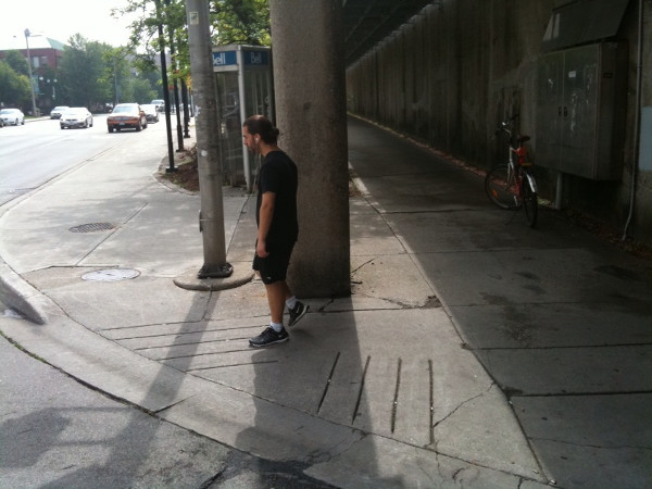
Hamilton GO Station. Sidewalk on left, multi-use path on right.
After the first building on Hughson, we turn right into the alley. Please note from the photograph the absolute lack of wayfinding.
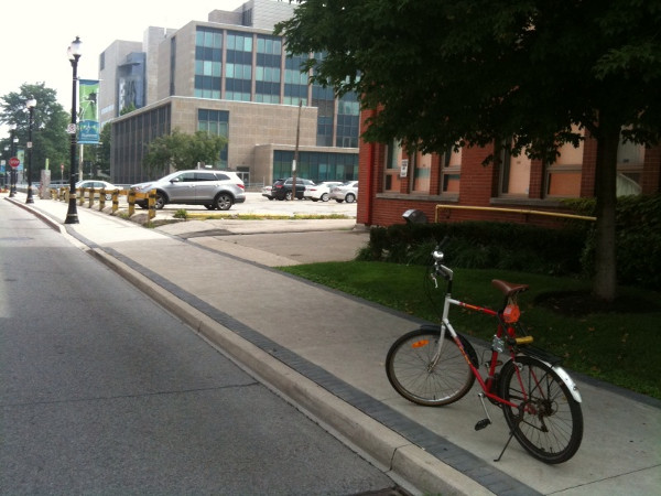
Entrance to three block long alley. Wayfinding non-existent
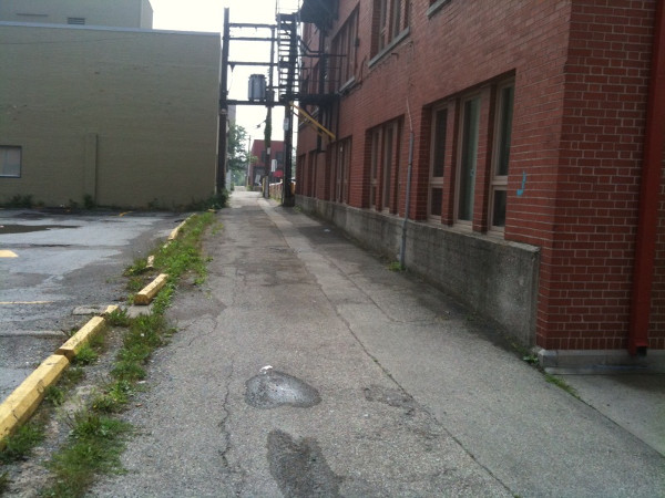
Alley entrance at Hughson.
This alley continues for three blocks. It crosses John Street, then crosses Catherine and ends at Walnut Street. As shown in the photograph, the last block between Catherine and Walnut streets is unpaved and overgrown.
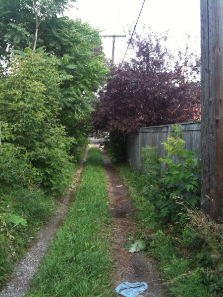
Last block between Catherine and Walnut. Alley is unpaved and overgrown.
From this unpaved alley, we turn left onto Walnut Street. Riding northbound along Walnut, we will cross Jackson Street and immediately turn right into the alley.
Although the alley continues to the east, we will turn left after one block, onto Ferguson. Then we ride north on Ferguson and its car-free extension across Main and King streets. This is a very pleasant part of the route.
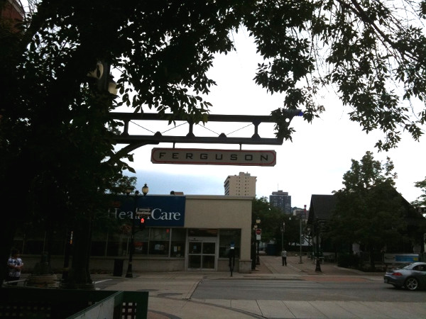
Car-free extension of Ferguson Street. Very nice!
Immediately after King Street, we will turn right after the first building and go into the alley. At this location, we encounter our one-and-only piece of bicycle-specific infrastructure for an alley. As shown in the photograph, this is the sign regulating traffic exiting the alley onto Ferguson.
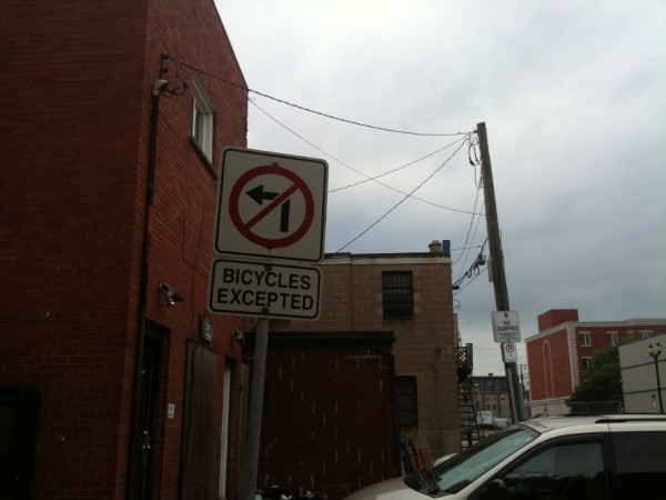
Exit westbound from alley onto Ferguson.
We now use this alley to ride east four and a half blocks. We pass Jarvis Street, cross Wellington Street, West Avenue and Victoria Avenue.
Then comes something interesting. Half way between Victoria and East Avenue we turn left at an alley/alley intersection! We are now headed north on one of the longest alleys in Hamilton.
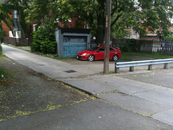
Alley/alley intersection
Riding in this alley, we cross King William Street, ride through Jack C. Beemer Park (very nice!), cross Evans Street and finally arrive at the Cannon Street bike lane which will take us to East Hamilton. Taa-daa!
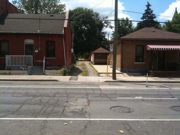
Our destination - Cannon Street cycle track
By the way, the alley we were in continues all the way north to the railway tracks at Birge Street. Turn right at Birge and we are only one block away from the pedestrian bridge over the tracks.
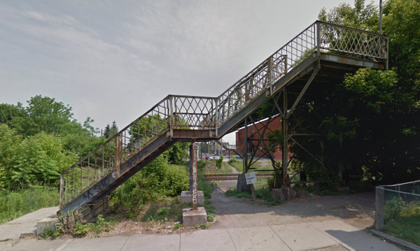
Pedestrian only bridge. No cycle infrastructure, so a desire line has formed across the tracks. (Image Credit: Google Street View)
Just before we get to the Cannon Street bike lane, an alternative is the route that I used to take before the Cannon Street bike lane was installed. What I did was turn right one block before Cannon and ride eastbound on Evans Street.
As we see on Google Maps, Evans is really an upgraded alley that got a street name.
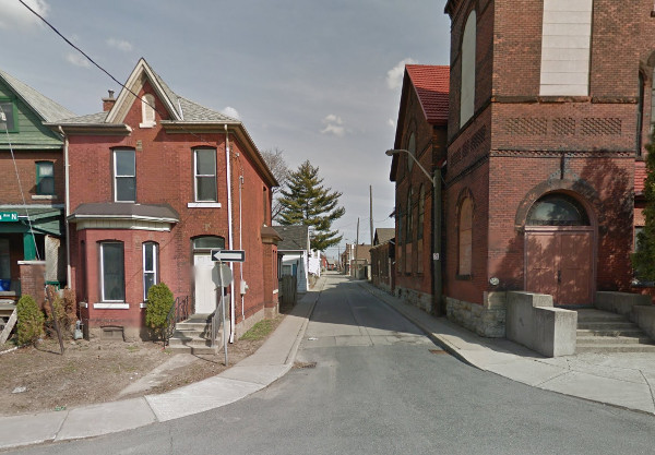
Evans at Victoria (Image Credit: Google Street View)
At Emerald Street, Evans takes a slight jog left and becomes a true alley. This alley then continues for another seven blocks to Sanford Avenue.
I will still sometimes take this alternate route, since this can be a pleasant low-stress alternative that bypasses the traffic lights at Wentworth and Sanford.
What is truly fascinating about taking this alternate route is that as we are riding east we see north-south intersecting alleys at the middle of most blocks. This forms a true alley transportation network for this part of Hamilton.
That's my commuting route to get to work. Bizarre, isn't it?
Although extremely insane by any rational route planning exercise, this route does have three advantages. Firstly, the alleys are a good example of the Dutch term "autoluwe." I'll follow David Hembrow's example and translate this as nearly car free.
Hamilton alleys are nearly car-free because they are uncomfortable and slow for a car driver to use. Two oncoming cars cannot pass each other. There is always a parallel road for car drivers that is much faster and more convenient for that car driver.
As a result, the number of motor vehicles in motion that I encounter in the alleys is usually zero. A second advantage is that the alleys are mid-block, and therefore entirely bypass traffic lights. Also, mid-block crossings are inherently safer since there are no turning motor vehicle movements such as are found at motor vehicle intersections.
Thirdly, the quality of paving in most of the alleys is excellent. It looks like the City did an alley paving project about 30 years ago. Most of the alleys have high-quality concrete paving that looks to be about that old. Due to the low volume of motor vehicle traffic, this concrete has aged well.
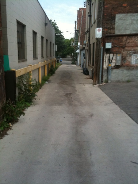
High quality concrete paving
Unfortunately, about 10-15 percent of the alleys have very poor surfaces or are entirely unpaved. A transportation route is only as good as its weakest link.
The disadvantages to using the alleys for transportation are numerous. But here goes.
No wayfinding. These alleys don't even have names. They are not on Google maps and not on Hamilton's bike map. The only map that I know of that shows the alleys is the SoBi map.. Unless one has detailed local knowledge and does thorough reconnaissance there is no way of knowing about these routes.
Crappy road surfaces. 10-15% of the alleys have potholes, cracks and other road surface issues or else are entirely unpaved. Any particular alley can be inconsistent, going from excellent one block to poor the next.
No lighting. I don't use this route when commuting during the winter when I would have to travel in the dark. But I would not use this route in the winter anyway because of...
Poor clearance of snow and ice in winter.
Unpleasant ambiance. For many people, particularly women and children, this could cause an issue with social safety.
Must yield right of way at all intersections.
No coherent network. Note all the twisting and turning for my commute route. Combined with the lack of wayfinding, this route is a maze and essentially impossible to use except as a commuter route for someone who uses it frequently.
For a car driver, the route to Cannon Street from Durand Park is easy and can be described in one 11-word sentence: "Take Herkimer to James Street, turn left and drive to Cannon." Also, no part of the car route is unpaved. Cycling should be the same.
Many articles have been written about the car parking protected bike lanes that the Durand Neighbourhood Association has recommended.
As per usual, the City is dragging its feet when it comes to vital safety improvements requested by the community.
For James Street, thanks to the "interesting" way that James was reverted back to two-way traffic, much of James has two lanes southbound and only one lane northbound.
Does this mean that northbound traffic is a perpetual traffic jam? No.
So there is plenty of room to reallocate road space. Jodenbreestraat in Amsterdam is an example of a street with a road allowance of similar width to James.
This same street treatment can be done to James Street to create a north-south transportation route that transforms the daily commute of myself (and many, many other people!) from a dysfunctional maze to sensible transportation.
By KevinLove (registered) | Posted July 22, 2015 at 01:27:23
Please accept my apologies for an error in the text. The "Alternate Route" should be described as bypassing the traffic lights at Wentworth and Sandford.
Fixing the infrastructure so that cyclists do not experience traffic lights is an important part of Dutch traffic planning.
By ergopepsi (registered) | Posted July 22, 2015 at 08:38:21
That is one sweet alley-filled ride IMO! The best part of the alley experience for me is no cars and no car fumes - they are quiet and stress free. I'm willing to endure the weeds and cracked concrete just to have that feeling of safety.
The worst part of course is that they are useless in the winter.
Just a little over ten years ago the garbage trucks ran down our alley to do the collection. I'm not sure why they decided to move the collection to the road but I suspect that it may have been because the city decided to stop plowing the alley. Kind of a shame as collecting in the alley must have been a lot easier than what they do now which is run around all the parked cars and contend with the sidewalk (also making two passes down the street).
By Pxtl (registered) - website | Posted July 22, 2015 at 09:25:12 in reply to Comment 112982
The worst part of course is that they are useless in the winter.
So are the bike lanes on Dundurn North, so this is not a rare failure.
By Pxtl (registered) - website | Posted July 22, 2015 at 09:49:13
Personally, I'd just take Ferguson and Cannon for most of that route. I tend to prefer simplicity over the reasons you choose alleyways.
And yeah, I've never seen anybody use the Birge/Emerald bridge unless there was a train stopped blocking the tracks.
I have trouble with the idea of the city working on alleyway road surfacing when many of the actual signed supported bike-routes are still a wreck - I mean, I was biking on Charlton the other day (in the part that may become a bike-lane once it gets out of permanent limbo) and hit a pot-hole big-enough that it would've wrecked a road-bike (fortunately I ride a rigid-fork mtb). It hurt.
Lighting, on the other hand, is a fantastic idea. It's 2015, LED technology has dropped the price of illumination spectacularly. We should be capitalizing on this to bring lighting to all of the city's urban trails and alleyways.
Comment edited by Pxtl on 2015-07-22 09:50:02
By KevinLove (registered) | Posted July 22, 2015 at 10:14:01 in reply to Comment 112985
Yes, I agree. Which is why my recommendation is to fix James Street, not any alley. The alleys may be useful for some trips. But transportation has to be from A to B for all origins and destinations.
By Pxtl (registered) - website | Posted July 22, 2015 at 10:46:39 in reply to Comment 112986
Point. James South and John South are still a confused mess from half-hearted conversion. I mean, the planners couldn't even seem to decide how many lanes to run up the Jolley Cut from John, so one lane is inexplicably hatched off.
My preferred approach would be just to make John handle the traffic and focus on the being the direct connection to the Jolley Cut (no more silly turn-lanes and Northbound-synched lights, just do 2 normal lanes in each direction) and make James South calmed down and cyclist-friendly. 2 car lanes, 1 parked lane, and 2 bike-lanes.
By jason (registered) | Posted July 22, 2015 at 15:24:06 in reply to Comment 112986
Hughson is also a good alternative to Cannon. Not sure why we don't have bike lanes on Hughson already from LIUNA to Hunter GO
By Pxtl (registered) - website | Posted July 22, 2015 at 15:35:03 in reply to Comment 112997
Hughson ends at Hunter Go (with no bike lanes at Hunter/Hughson), while James keeps on going South to the planned lanes on Charlton/Herkimer. That said, James North will be really complicated when the LRT comes in.
Say Hughson north of Jackson, and James south of Jackson?
By RobF (registered) | Posted July 22, 2015 at 15:54:31
I don't commute via bike at the moment, but I follow similar routes to get from where I live in the North End to Ottawa Street or to anywhere Southwest of King and James. We really could use a serious plan to build a "back-bone" cycling network that allows for long-distance, grid-like travel in east-west and north-south directions. Not going to hold my breath waiting for it to happen ...
In the meantime, could we get on with converting Mary St (and other North-South streets) to 2-way, so that those of us cycling from North of Barton can use the light to go southbound to the Cannon bike lanes, etc.
By RobF (registered) | Posted July 22, 2015 at 15:57:17 in reply to Comment 112998
I'd vote for Hughson ... I can't see how you'd fit bike lanes and the LRT on James North between York/Wilson and Barton. Besides, I find riding past rows of parked cars on retail streets nerve racking. Too much risk of being doored.
By Pxtl (registered) - website | Posted July 22, 2015 at 16:03:57 in reply to Comment 113000
Like I said, switch over at Jackson, which is a nice quiet bike-friendly street too. Then you can go all the way from Liuna Station to St. Joe's. Then you look at getting one of the 3 different mountain ways available at the South end of James safe for bikes (James Mountain Road, the Jolley Cut, or the disused John->Upper James trail).
At the same time, streamline John street to carry more Southbound Jolley Cut traffic.
Comment edited by Pxtl on 2015-07-22 16:04:22
By RobF (registered) | Posted July 22, 2015 at 16:32:09 in reply to Comment 113001
I don't disagree ... I just don't get south of the Hamilton GO Station very often, so I wasn't really thinking about the rest of the suggested route. LRT will bring some pretty big changes to James North, so perhaps someday it will be friendly to cycling ... from the escarpment to waterfront is an appealing spine for a future bike network. At the moment I think Ferguson figures in the City's plans for this purpose. I just don't know many people who use it that way. Eventually Strachan is supposed to be a greenway corridor with a multi-use path to connect to Bayfront Park and the waterfront trail, etc.
By Pxtl (registered) - website | Posted July 22, 2015 at 17:17:02 in reply to Comment 113003
Ferguson seems like it was too much top-down engineering instead of bottom up. City decided that this would be a good place for a north/south bike route, and didn't ask if this is where cylcists want to go north/south.
Eisenberger spent many millions on that bridge, and the road itself has that elaborate brick surface which couldn't be cheap either. How many cannon bike tracks could have been built with the money spent on Ferguson's cyclist infrastructure? I work at HGH and Ferguson is connected to HGH by Barton, and I just use Wellington/Victoria to get to Cannon rather than ride on Barton.
I mean, when you get down to King, Ferguson is fantastic, but it seems to get kind of pointless as you travel North because there isn't all that much there. Then again, I don't live in the North End, folks up there may disagree.
By walter_hbd (registered) | Posted July 22, 2015 at 20:50:08
I live right around James, and I usually cut over to John since there's two lanes, most drivers pass safely, but I'm going their speed downhill anyways
By KevinLove (registered) | Posted July 22, 2015 at 22:36:14 in reply to Comment 112989
Also very true about the half-hearted conversion. These streets used to be two-way; they were designed to be two-way. Not rocket science. But, you know, Hamilton... sigh...
By John Neary (registered) | Posted July 22, 2015 at 22:55:21 in reply to Comment 113004
Ferguson was a pointless vanity project. Between the tunnel under the TH&B tracks (where cyclists are supposed to dismount), the absence of a traffic light at Main (or event a proper curb cut on the north side, the bumpy brick surface through Beasley, and the high bridge over the CN tracks, it's a terrible route for cyclists.
Walnut/Mary is a much better route, or at least it would be if we could get a simple 2-way reversion of Mary from King William to Barton.
By jason (registered) | Posted July 22, 2015 at 23:13:30 in reply to Comment 113007
I actually enjoy Ferguson, despite the ridiculousness at Main St. I love the connection from the waterfront to Corktown Park. It's a perfect connecting ride from the waterfront trail over to the rail trail at Corktown Park. There was supposed to be bike-friendly stairs built at the bottom of Ferguson up to Sam Lawrence Park. How this part never came to be is astonishing. It's the perfect central city/ central Mountain connector, and would offer lower city residents a chance to enjoy the stunning beauty in Sam Lawrence.
Add the stairs and fix Main St and it would be a great route.
The CN bridge wasn't done well either, as you've noted. Way too steep. I would also like to see speed humps along it's entirety. Make it a true neighbourhood greenway route.
By RobF (registered) | Posted July 23, 2015 at 09:24:31 in reply to Comment 113004
Ferguson seems like it was too much top-down engineering instead of bottom up. City decided that this would be a good place for a north/south bike route, and didn't ask if this is where cylcists want to go north/south.
Ain't that the truth.
By Cultosaurus (registered) | Posted July 26, 2015 at 17:11:48 in reply to Comment 113087
That is both idiotic and totally impractical and will not solve the issue at hand. Try again troll.
By Cultosaurus (registered) | Posted July 27, 2015 at 10:42:03 in reply to Comment 113089
Why would I go look up stats for an idiot who probably couldn't interpret them? No politician is going to ever try to tax cyclists, it doesn't make any sense, but you either already know that and are trolling (most likely) or you are embarrassingly uniformed and clueless. Maybe it's both.
By mdrejhon (registered) - website | Posted July 27, 2015 at 21:38:38
CycleTO's future bike paths for Toronto.
http://urbantoronto.ca/forum/attachments...
Do we have a master plan for Hamilton's cycle path expansion?
You must be logged in to comment.
There are no upcoming events right now.
Why not post one?