We can do a better job of balancing the understandable desire for cut-through drivers to save a bit of time with the equally-understandable desire of local residents to have a safer, more inclusive street for all uses.
By Nicholas Kevlahan
Published August 26, 2016
This article has been updated.
This past week, the Beckett Drive escarpment access (also known as the Queen Street Hill) has been closed for rock scaling and preventative maintenance work. That has given us an important insight into the character of the normal traffic on this busy arterial.

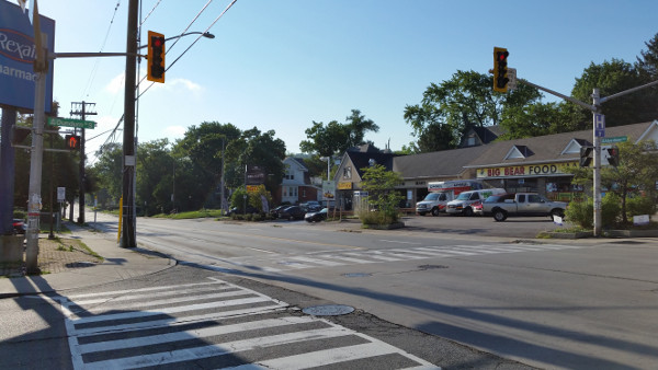
Aberdeen at Dundurn looking east during AM rush hour, August 26, 2016 (Image Credit: Nicholas Kevlahan)
I have been astonished each morning, when waiting at the traffic signal at Dundurn and Aberdeen during morning rush hour, to see absolutely no vehicle traffic on Aberdeen travelling westbound toward Highway 403!
There have been literally no cars waiting at the red light.
This shows clearly and concretely that essentially all the morning rush hour traffic on Aberdeen consists of mountain residents trying to get to Highway 403.

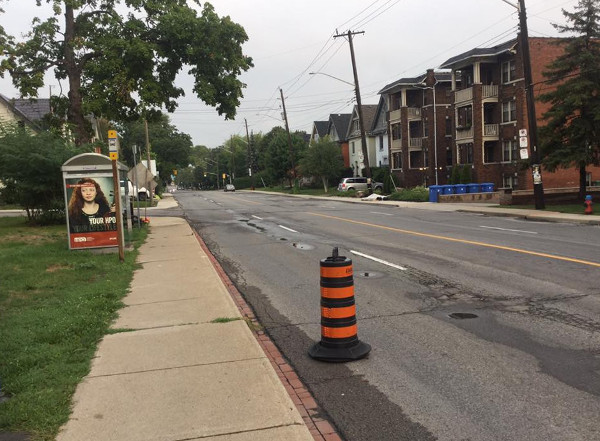
Aberdeen just west of Queen looking west during AM rush hour, August 25, 2016 (Image Credit: Maureen Wilson)
Beckett Drive and Aberdeen is clearly serving as a slight shortcut for mountain residents. But is it even a shortcut?
According to Google maps, someone living at Bendamere and Upper Paradise in the middle of the west mountain should actually be taking the Lincoln M. Alexander Parkway (Linc) as the fastest route to the Highway 403/Aberdeen interchange (eight minutes with no traffic).
Google doesn't even propose Beckett Drive as an option!

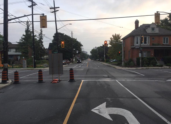
Queen just south of Aberdeen looking north during AM rush hour, August 25, 2016 (Image Credit: Maureen Wilson)
Even for someone living right at the top of Beckett Drive at Fennell and Garth, Google says it is six minutes via Aberdeen and nine minutes via Linc/403 to the 403/Aberdeen interchange (without traffic).
That is, the biggest time savings based on starting location is just three minutes (assuming relative travel times are similar with traffic).
This problem is not exclusive to Aberdeen, either. One of my colleagues who lives in the west end of Dundas made a similar observation about his neighbours preferring to use Main Street to get to east Hamilton, even though Google maps actually advises taking the Linc/Red Hill Valley Parkway (RHVP) as the fastest route.
We've spent hundreds of millions of dollars on the Highway 403/Linc/RHVP/QEW ring highway system precisely in order to provide regional driving connections around the various parts of the city so that neighbourhood streets can provide a better balance between cut-through traffic and local transportation needs.
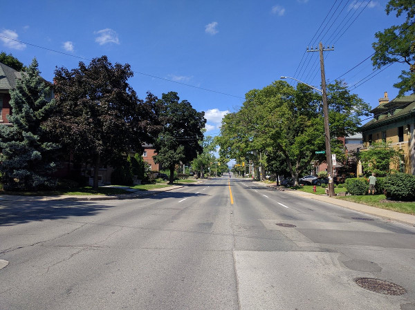
Aberdeen is four lanes wide - two in each direction - with very narrow sidewalks right next to the outside driving lanes for most of its length between Queen and Longwood. It has no bike lanes, even though it serves as a connection for bike trips using the Rail Trail connection with west Hamilton next to the CP railyard.
A few years ago, a cyclist was seriously injured on Aberdeen taking this very route home from work at McMaster when he was struck from behind by a driver.

Aberdeen looking west from Sprucecide in late morning on August 22, 2016 (Image Credit: Ryan McGreal)
I believe we can do a better job of balancing the understandable desire for cut-through drivers to save a bit of time with the equally-understandable desire of local residents to have a safer, more inclusive street for all uses.
Through drivers have alternatives to short-cutting through Kirkendall, whereas people living in the neighbourhood have no alternative but to brave the street. As such, the street should accommodate local active transportation as well as through traffic, instead of sacrificing the former to facilitate the latter.
Related:
Update, August 29, 2016: I have discovered that you can get typical travel times at different times of day from Google Maps.
Leaving at 8:00 AM, the typical travel times from Bendamere and Upper Paradise to to Highway 403 and Longwood is 10-14 minutes (average 12 minutes) via Highway 403.
The Garth/Beckett/Aberdeen alternative is not given as an option, but if we force that route we find 9-14 minutes (average 11.5 minutes) - although I couldn't get it to go via Aberdeen to the actual Highway, so I stopped at Longwood!
Earlier, at 7:20 AM, the route via Highway 403 takes 13 minutes on average (10-16 minutes) and Aberdeen takes 11.5 minutes (9-14 minutes). By 9:00 AM, the estimated times are exactly the same.
Overall, the expected times are the same within a minute or two for the morning rush hour. Taking Abderdeen is not a reliable shortcut for someone coming from the central west mountain - it must just feel like one.
Even for someone living at the top of Beckett Drive at Fennell and Garth at 8:00 AM, the times are 8-14 minutes (average 11 minutes) via Aberdeen and 10-16 minutes (average 13 minutes) via the Linc/403.
Again, the times are essentially the same, even for someone living right at the top of Beckett Drive.
By Pxtl (registered) - website | Posted August 26, 2016 at 10:14:06
To be fair, they're also going to McMaster/Westdale, not just the 403, although they could do that on the 403 too, or take Bay to King.
By kevlahan (registered) | Posted August 26, 2016 at 10:31:11 in reply to Comment 119874
Yes, that's true, but I meant "403" as in the 403/Longwood intersection (or Main/Longwood), not necessarily continuing onto the 403 eastbound to Toronto.
By GrapeApe (registered) | Posted August 26, 2016 at 14:17:03
Does anyone know the status of the Aberdeen Road Diet? The participatory budget for ward 1 directed my vote for it (referencing RTH) as " under the scope of a pending traffic-management plan"... what plan?
By KevinLove (registered) | Posted August 26, 2016 at 14:18:19
...the street should accommodate local active transportation as well as through traffic
I strongly disagree with this statement. Through traffic in residential areas is only acceptable if it is by walking, cycling or public transit. Cut-through "rat-running" car drivers are never acceptable in residential areas.
Here is a video and description of how rat-running has been systematically eliminated on residential streets in an entire country:
http://www.aviewfromthecyclepath.com/201...
And here is a video showing an example of how to use a ring road, just like our 403/Link/Red Valley/QEW/Burlington Street ring road. The specific part to watch is from 2:00 to 4:00, but the entire video is well worth viewing.
http://www.streetfilms.org/groningen-the...
In short, rat-running car drivers have no place on a residential street such as Aberdeen. Rat-running can and should be prevented on this street. The sky will not fall. I promise.
Comment edited by KevinLove on 2016-08-26 14:20:14
By Jane (registered) | Posted August 27, 2016 at 06:31:54
Not only do they use Aberdeen, they then take another short cut, well over the speed limit, down Stanley to avoid the lights at Aberdeen and Dundurn.
By The99Percent (registered) | Posted August 29, 2016 at 08:08:35
Lol @ the idea that Beckett isn't a shortcut for the folks heading west from the mountain. My office is just off the 403 Aberdeen exit, and it is impossible to make it down in under 25 minutes using the linc/403 because of the bottle neck in Ancaster.
Beckett on the other hand cuts the drive to about 15-20 minutes if I leave at the same time.
By mountain66 (registered) | Posted August 29, 2016 at 09:50:26 in reply to Comment 119889
This may be true but maybe the city should look at the cause of the increased traffic on Aberdeen. I suspect they would find it is a direct result of urban sprawl on the Upper Mountain south of the Linc. I grew up in a rural community that relied on well water, as a result the town would not issue building permits as the water supply could not support it. If the city knows Hwy 403 cannot be expanded due to the escarpmnet and the existing streets are at capacity, why allow more development on the south Mountain until it is solved?
By kevlahan (registered) | Posted August 29, 2016 at 11:18:15 in reply to Comment 119890
But why would people living south of the Linc cross over the Linc and then drive all the way across the Mountain from the Linc to the escarpment, down Beckett Hill (just one lane in each direction and slow at rush hours) and along Aberdeen to the get to the 403/Main instead of taking the Linc/403? It doesn't make any sense ...
By DBC (registered) | Posted August 29, 2016 at 11:48:34 in reply to Comment 119892
But in Hamilton it unfortunately does make sense.....at rush hour the 403 is very slow and congested and we have brilliantly created a city road network that is faster than staying on the highway.
Cutting through the city allows drivers a faster route - or at least they perceive it to be so.
By kevlahan (registered) | Posted August 29, 2016 at 12:29:18 in reply to Comment 119893
That is perverse! It's crazy that taking city streets is actually quicker than the freeeways at rush hour.
Now (at 13:26) the comparative times for someone living at Garth and Stonechurch to 403/Longwood are:
12 minutes via the Linc/403 (11 minutes with no traffic) and 14 minutes via Garth/Beckett/Aberdeen (13 minutes with no traffic)
so the Linc/403 route is two minutes faster off peak.
Google gives exactly the same estimated travel times for both routes for someone leaving at 8:00am: 12-20 minutes. So, again, there is typically no advantage to taking city streets.
For someone leaving at 8:20am the travel time is actually a bit longer on Garth/Beckett: 12-22 minutes compared to 12-20 minutes on the Linc/403.
Comment edited by kevlahan on 2016-08-29 12:33:21
By fast_eddie (registered) | Posted August 29, 2016 at 14:26:08
The only problem I have with this article is the individual was observing during a time when school is not in session. I think if this was done in September or October, your pictures would look markedly different.
What concerns me more is the consultant's report about how LRT will affect Aberdeen for westwardly car traffic. I am very interested to hear the thoughts of this blog and other traffic management "specialists" on the validity of the consultant's forecast.
Comment edited by fast_eddie on 2016-08-29 14:30:08
By kevlahan (registered) | Posted August 29, 2016 at 14:33:11 in reply to Comment 119898
I've updated the article with typical travel times at morning rush hour which show that Beckett/Aberdeen is at best a minute or two faster than the Linc/403 from the central West Mountain and is not even a reliable shortcut.
I agree that there would likely be more cars on Aberdeen during September/October when McMaster is in session (the number of people driving to EK on Aberdeen wouldn't have much of an effect), but it is nevertheless striking that there were literally zero cars waiting at the red light on Aberdeen at the morning rush hour ... far less than the previous week.
Recall that when Beckett drive was closed for re-building from June to November 2013 Aberdeen was also empty:
https://www.raisethehammer.org/article/1...
This already showed that almost all the morning rush hour traffic on Aberdeen is from Beckett Drive.
Regarding the effects of LRT, the preliminary traffic study showed a bit of increase in congestion but that was before any attempts to improve traffic flow along Main/King. Also, since almost all the morning rush hour traffic is from the Mountain it is possible that Mountain residents will stop using Aberdeen once it becomes obvious that it really is quicker to take the Linc/403. I'm not sure if that was included in the model.
Comment edited by kevlahan on 2016-08-29 14:36:38
By fast_eddie (registered) | Posted August 29, 2016 at 15:06:36 in reply to Comment 119899
Living in the area, yes, it was nice to see how "calm" Aberdeen was. Personally, I only find Google travel time accurate when travelling highway, not as often on local, but that's just my experience.
On a side note, it really irked me when a well-known local radio host, bragged about how she went around the sign the first time to get back up the hill during the construction period, but wasn't as lucky the next day. I love karma!
By KevinLove (registered) | Posted August 29, 2016 at 15:16:06 in reply to Comment 119894
This problem is easily corrected with nice solid steel safety bollards enforcing Zero Tolerance of rat-running.
By mountain66 (registered) | Posted August 29, 2016 at 21:58:40
What is interesting was that when Beckett Dr was closed the traffic didn't go to the 403. they went East & tried to use James Mountain Rd. This resulted in traffic backed up as far as Brantdale in the morning & afternoon. When they found they were backed up they tried to cut through our neighbourhood, which is truly residential with only 1 lane each way and parking. The result was cars backed up over 3 blocks because a left turn at Inverness West & Upper James is very difficult. It resulted in at least one accident at that corner. The only real solution is to improve HSR service on the Mountain & reduce the cars. For example the "A" line bus runs on a 30 minute schedule while the "B" line runs 10 minutes. Set the "A" line at 10 minutes and I think more people would use it. For example my daughter works in Toronto & uses GO transit, HSR worked in the morning but coming home she would wait 30 minutes as she could see all the Mountain Buses bunched together from the train and the next ones would be 30 minutes. She now drives to West Harbour as who wants to wait 30 minutes after a long commute? Stagger the buses or improve service after 6PM and she would gladly use the HSR.
By kevlahan (registered) | Posted August 30, 2016 at 08:40:07 in reply to Comment 119903
That's very strange: I would have thought that after the first day people (at least those going to the 403/Westdale) would have realized that taking the Linc/403 was a much better choice.
I agree that the City needs to start actually investing in its bus system, especially on the mountain. The A-line is in a vicious circle of low ridership and low frequency. It is ridiculous to promote a once every 30 minutes bus service as some sort of higher order express bus! But, as far as I know, it was really introduced primarily as a subsidy to the cargo companies at the airport, to help their employees get to work, not as a proper express bus service for the City.
They are refusing to increase the ratepayer contribution and relying exclusively on fare increases and provincial funding, which is a losing proposition.
By Pxtl (registered) - website | Posted August 30, 2016 at 09:33:52 in reply to Comment 119906
Imho, part of the problem with the A-line is half the route is a waste of time. There just aren't that many people going to the airport. They could easily up the frequency if they ditched the dead half of the route.
By GrapeApe (registered) | Posted August 30, 2016 at 10:31:46 in reply to Comment 119912
It could also be segmented such that the "dead" half had it's own 30-60 minute leg.
By kevlahan (registered) | Posted August 30, 2016 at 10:51:00 in reply to Comment 119914
I agree that there should be 10-15 minute service on the urban part north of the Linc to downtown and 30 minute service from the Linc to the Airport.
By JasonL (registered) | Posted August 30, 2016 at 10:55:32 in reply to Comment 119915
I would much rather see the A-Line head to Limeridge Mall. Much higher ridership and potential ridership than big parking lots on Upper James and an empty airport.
By mountain66 (registered) | Posted August 30, 2016 at 10:58:21 in reply to Comment 119914
Exactly, perhaps what is needed is an HSR hub somewhere around Upper James and Rymal with a car pool lot. When I worked in Nanticoke we had to bounce around and ask permission to park in the plaza lots and churches in the Upper James & Rymal area. With a car pool lot we could have just parked and not worried about blocking snow clearing when we were on shift in the winter.
There might be room in the Fortino's plaza.
Comment edited by mountain66 on 2016-08-30 10:59:07
By Pxtl (registered) - website | Posted August 30, 2016 at 11:57:06 in reply to Comment 119917
We already have Lime Ridge Mall's bus platform, numerous buses meet there. Personally, I'd look at adding Bus Bypass shoulders to the Linc and have all the buses on the mountain use that as an express-route to rendezvous there, rather than slogging along Mohawk or Stone Church. Designate some of the back parking at LR mall as commuter-allowed parking. Then have the Airport bus depart from there.
By Streeter (registered) | Posted August 30, 2016 at 12:46:57 in reply to Comment 119916
Agreed, Limeridge Mall makes more sense, there is a higher population density along that stretch as well. But then again, how would all the bus riders get to the 2 km + auto mall that is Upper James to buy a car and then get smoked by the very model they were headed to buy while trying to cross the road?
By mountain66 (registered) | Posted August 30, 2016 at 12:50:49 in reply to Comment 119906
My wife & I found it very strange indeed. We thought that by Tuesday things would be semi normal but it continued on even to Friday afternoon. If I had thought it was going to be that bad I would have suggested they post a warning sign at the top of Beckett drive advising people to expect major delays on James Mountain Rd between 7 AM - 9:30 AM and 4-6 PM & use 403 or the Claremont access as alternates.
By mountain66 (registered) | Posted August 30, 2016 at 12:55:50
Sorry to kind of hijack the thread. I understand the city has monitoring cameras at various intersections, perhaps they could install traffic warning signs similar to what you see on the 400 series highways and advise drivers going past the Linc of the difference in time using the Linc-403 instead of using Beckett Dr. & Aberdeen.
By mdrejhon (registered) - website | Posted August 30, 2016 at 14:17:24 in reply to Comment 119914
I like the idea of a much more frequent A-Line Express (perhaps end at Limeridge Mall for now) that's all-day 365 days per year -- with a more occasional A-Line express that goes ahead to the airport.
Call it 10 Express and 10A Express -- with the A being Airport.
It'll be a good lead-up for 10 Express being replaced by the suggested A+T hybrid LRT (an A-Line LRT with a T-line stub to Limeridge). This is a good incremental step before the full-length A-Line LRT.
In fact, I'd even go as far as suggest that this be "Phase 2 Plus" -- additional funding for Phase 2 to make this happen concurrently with the Eastgate LRT extension, construction of this could begin 2024 and be complete by 2027-9(ish).
In fact, it may be even be possible to do EA's after a favourable 2018 election, get it funded during 2018-2022 (e.g. Trudeau re-election) and begin prep by drilling the tunnel ramp thru the escarpment before 2024 (~5 degree slope that was mentioned elsewhere), to get a head-start on corridor for 2024.
Ottawa is starting their Phase 2 LRT immediately after Phase 1 LRT, and Hamilton can too.
So, yes, it is a good idea to start ramping up bus services (10-year Rapid Ready), by terminating A-Line 10 Express (15-min or better) at Limeridge Mall, with a few A-Line 10A Express all the way to the Airport (30-60min service).
This will increase bus ridership for a realistic LRT line (A+T hybrid single route), which can more cheaply occur before the full-length A-Line LRT, with better ridership-per-kilometer utilization.
Comment edited by mdrejhon on 2016-08-30 14:55:26
You must be logged in to comment.
There are no upcoming events right now.
Why not post one?